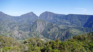
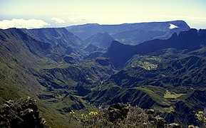
The Pitons, Cirques and Craters of Réunion coincide with the core area of Réunion National Park. The property covers more than 100,000 hectares, or 40% of Réunion Island. Réunion is made up of two adjacent volcanoes and is located in the south-west of the island. Indian Ocean. Dominated by two towering volcanic peaks, massive walls and three cliff-encircled cirques, the property includes a variety of rugged terrains and impressive cliffs, forested canyons and basins, forming a visually striking landscape. It is a natural habitat for a wide variety of bird species and a high degree of endemism. There are subtropical rainforests, cloud forests and heather forests, forming a striking and visually fascinating combination of ecosystems and landscape features.
| Commons category |
Réunion National Park |
| inception |
2007-01-01T00:00:00Z |
| highest point |
Piton des Neiges |
| coordinate location |
Point(55.5 -21.15) |
| located on terrain feature |
Réunion |
| official website |
http://www.reunion-parcnational.fr |
| protected areas INPN Code |
FR3300009 |
| area |
1054.47 |
| mountain range |
Piton de la Fournaise massif |
| mountain range |
Massif du Piton des Neiges |
| uses |
1029448175 |
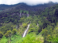
| image |
http://commons.wikimedia.org/wiki/Special:FilePath/Voile%20de%20la%20Mari%C3%A9e%20Salazie%201.JPG |
| ISNI |
0000 0000 9304 0597 |
| executive body |
Réunion National Park |
| page at Belarus Globe website |
FR3300009 |
| number of rooms |
lccn-no2009136032 |
| office held by head of the organization |
http://g.co/kg/m/04lhgxd |
| part of |
Pitons, cirques and remparts of Reunion Island |
 and buffer zone (green) of Réunion National Park.jpg)
.JPG)