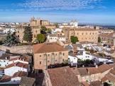
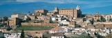
Old Town of Cáceres
World Heritage
Spain
🎧 Listen to Introduction
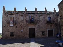
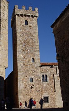
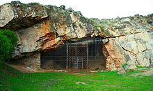
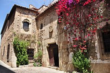
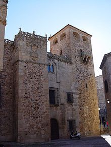
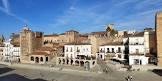
The city's architectural style is a mix of Roman, Islamic, Northern Gothic and Italian Renaissance styles, reflecting the history of wars between Moors and Christians. Of the 30 towers built during the Muslim period, the Bujako Tower is the most famous.

Poem of the heritage generated by AI
Intangible culture related to the heritage
China tourist attractions related to the heritage
World heritage related to the heritage
Show more related heritage
Information extracted from Wikidata
| official website | http://www.ayto-caceres.es |
| topic's main category | Category:Cáceres, Spain |
| Commons gallery | Cáceres |
| page banner | http://commons.wikimedia.org/wiki/Special:FilePath/WV%20banner%20Caceres.jpg |
| Dewey Decimal Classification | 2--4628 |
| WOEID | 12694519 |
| official name | Cáceres |
| native label | Cáceres |
| elevation above sea level | 459 |
| area | 1750330000 |
| collage image | http://commons.wikimedia.org/wiki/Special:FilePath/Collage%20de%20C%C3%A1ceres.jpg |
| nighttime view | http://commons.wikimedia.org/wiki/Special:FilePath/Parte%20antigua%20C%C3%A1ceres.jpg |
| publication date | 1930-01-01T00:00:00Z |
| winter view | http://commons.wikimedia.org/wiki/Special:FilePath/C%C3%A1ceres%20bajo%20la%20nieve%202.JPG |
| category for maps | Hostivař |
| Provenio UUID | ffcf0b3f-4950-4f3a-b2f4-37b1b1ca09c0 |
| uses | 4085107-2 |
| image | http://commons.wikimedia.org/wiki/Special:FilePath/C%C3%A1ceres%20panor%C3%A1mica%20-%20panoramio%20%28cropped%29.jpg |
| flag image | http://commons.wikimedia.org/wiki/Special:FilePath/Bandera%20de%20C%C3%A1ceres.svg |
| shares border with | Azurém |
| shares border with | Hufeisensiedlung |
| shares border with | Category:Maps of Yaroslavl |
| shares border with | Casas de Don Antonio |
| shares border with | Talaván |
| shares border with | Torrequemada |
| shares border with | Puebla de Obando |
| shares border with | Botija |
| shares border with | Trujillo |
| shares border with | Mérida |
| shares border with | Montánchez |
| shares border with | Santa Marta de Magasca |
| shares border with | Jewish Quarter of Třebíč |
| coat of arms image | http://commons.wikimedia.org/wiki/Special:FilePath/Coat%20of%20Arms%20of%20C%C3%A1ceres.svg |
| twinned administrative body | Portalegre |
| twinned administrative body | Cova del Pi |
| twinned administrative body | Blois |
| twinned administrative body | Piano di Sorrento |
| twinned administrative body | Quillota Province |
| executive body | Cáceres |
| location of creation | Cáceres |
| WOEID | 12694519 |
| IPA transcription | 2050262 |
| ground level 360 degree view | http://commons.wikimedia.org/wiki/Special:FilePath/Parte%20antigua%20C%C3%A1ceres.jpg |
| McCune-Reischauer romanization | caceres |
| number of rooms | lccn-n79023198 |
| topographic prominence | 10477 |
| office held by head of the organization | http://g.co/kg/m/01253d |
| postal code | 10001–10005 |
| postal code | 10001 |
| part of | Extremadura |
| Commons category | Cáceres |
| licence plate code | CC |
| coordinate location | Point(-6.371111111 39.473055555) |
| named as | Cáceres (Španělsko) |
| INE municipality code | 10037 |
| population | 88245 |
| determination method | saltire |
| point in time | 2004-01-01T00:00:00Z |
| population | 87088 |
| determination method | saltire |
| point in time | 2003-01-01T00:00:00Z |
| population | 95814 |
| determination method | saltire |
| point in time | 2016-01-01T00:00:00Z |
| population | 90802 |
| determination method | saltire |
| point in time | 2007-01-01T00:00:00Z |
| population | 95925 |
| determination method | saltire |
| point in time | 2013-01-01T00:00:00Z |
| population | 96126 |
| determination method | saltire |
| point in time | 2019-01-01T00:00:00Z |
| population | 95668 |
| determination method | saltire |
| point in time | 2012-01-01T00:00:00Z |
| population | 95026 |
| determination method | saltire |
| point in time | 2011-01-01T00:00:00Z |
| population | 96255 |
| determination method | saltire |
| point in time | 2020-01-01T00:00:00Z |
| population | 95855 |
| determination method | saltire |
| point in time | 2014-01-01T00:00:00Z |
| population | 90218 |
| determination method | saltire |
| point in time | 2006-01-01T00:00:00Z |
| population | 89029 |
| determination method | saltire |
| point in time | 2005-01-01T00:00:00Z |
| population | 96068 |
| determination method | saltire |
| point in time | 2018-01-01T00:00:00Z |
| population | 93131 |
| determination method | saltire |
| point in time | 2009-01-01T00:00:00Z |
| population | 94179 |
| determination method | saltire |
| point in time | 2010-01-01T00:00:00Z |
| population | 95617 |
| determination method | saltire |
| point in time | 2015-01-01T00:00:00Z |
| population | 84439 |
| determination method | saltire |
| point in time | 2002-01-01T00:00:00Z |
| population | 95917 |
| determination method | saltire |
| point in time | 2017-01-01T00:00:00Z |
| population | 82034 |
| determination method | saltire |
| point in time | 2001-01-01T00:00:00Z |
| population | 92187 |
| determination method | saltire |
| point in time | 2008-01-01T00:00:00Z |
| described by source | The Nuttall Encyclopædia |
| stated as | Caceras |
| female population | 50059 |
| determination method | census |
| point in time | 2019-01-01T00:00:00Z |
| male population | 46067 |
| determination method | census |
| point in time | 2019-01-01T00:00:00Z |
| demonym | cacereña |
| applies to part | feminine singular |
| demonym | cacereño |
| applies to part | masculine singular |
| head of government | Luis Salaya |
| start time | 2019-06-15T00:00:00Z |