Historic Centre of São Luís
World Heritage
Brazil
🎧 Listen to Introduction
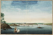
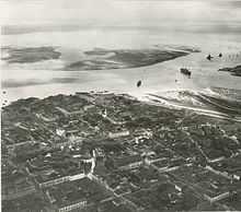
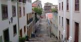
This historic city was founded by the French in the late 17th century, occupied by the Dutch and then ruled by the Portuguese. Its core area has completely preserved its original rectangular street layout. Due to the economic stagnation in the early 20th century, a large number of fine historical buildings have been preserved, making it an outstanding example of an Iberian colonial town.
.jpg)
Poem of the heritage generated by AI
Intangible culture related to the heritage
China tourist attractions related to the heritage
World heritage related to the heritage
Show more related heritage
Information extracted from Wikidata
| location of creation | São Luís |
| U.S. National Archives Identifier | 10037858 |
| IPA transcription | 3533191 |
| catalog code | 9210 |
| number of rooms | lccn-n81140092 |
| office held by head of the organization | http://g.co/kg/m/01zpkp |
| postal code | 65000-000 |
| Commons category | São Luís (Maranhão) |
| local dialing code | 98 |
| inception | 1612-09-08T00:00:00Z |
| coordinate location | Point(-44.302777777 -2.53) |
| official website | http://www.saoluis.ma.gov.br |
| topic's main category | Category:São Luís, Maranhão |
| Commons gallery | São Luís |
| page banner | http://commons.wikimedia.org/wiki/Special:FilePath/WV%20banner%20Sao%20Luis%20St%20Antonio%20fort.jpg |
| Human Development Index | 0.768 |
| U.S. National Archives Identifier | 10037858 |
| demonym | são-luisense ou ludovicense |
| elevation above sea level | 4 |
| area | 827.141 |
| uses | 4394684-7 |
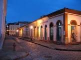
| image | http://commons.wikimedia.org/wiki/Special:FilePath/SaoLuis-Street2.jpg |
| instance of | big city |
| flag image | http://commons.wikimedia.org/wiki/Special:FilePath/Bandeira%20de%20S%C3%A3o%20Lu%C3%ADs.svg |
| shares border with | Paço do Lumiar |
| coat of arms image | http://commons.wikimedia.org/wiki/Special:FilePath/Bras%C3%A3o%20de%20S%C3%A3o%20Lu%C3%ADs.svg |
| legislative body | Municipal Chamber of São Luís |
| locator map image | http://commons.wikimedia.org/wiki/Special:FilePath/Maranhao%20Municip%20SaoLuis.svg |
| executive body | São Luís (Maranhão) |
| part of | Monument to Cesare Lombroso |
| start time | 1614-10-26T00:00:00Z |
| end time | 1615-11-02T00:00:00Z |
| population | 1014837 |
| determination method | census |
| point in time | 2010-01-01T00:00:00Z |
| population | 1073893 |
| determination method | estimation process |
| point in time | 2015-07-01T00:00:00Z |
| population | 870028 |
| determination method | census |
| point in time | 2000-08-01T00:00:00Z |
| population | 1108975 |
| determination method | estimation process |
| point in time | 2020-07-01T00:00:00Z |