Tassili n'Ajjer
World Heritage
Algeria
🎧 Listen to Introduction
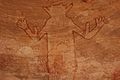
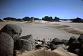
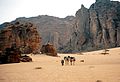
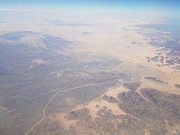
The site is located in a geologically significant and bizarre lunar landscape and contains the world's most important collection of prehistoric cave art. More than 15,000 drawings and engravings document climate change, animal migrations and the evolution of human life. The rock formations on the edge of the Sahara Desert date from 6000 BC to the first few centuries of the modern era. The geological formations here are spectacular, with eroded sandstone forming a "rock forest".
# Climate Change
# Sahara Desert
# Prehistoric Cave Art
# Animal Migration
# Human life evolution
# Rock Forest


Poem of the heritage generated by AI
Intangible culture related to the heritage
China tourist attractions related to the heritage
World heritage related to the heritage
Show more related heritage
Information extracted from Wikidata
| image | http://commons.wikimedia.org/wiki/Special:FilePath/Tassili%20Desert%20Algeria.jpg |
| located in the administrative territorial entity | Lanarkshire |
| executive body | Tassili n'Ajjer |
| IPA transcription | 4183290 |
| office held by head of the organization | http://g.co/kg/m/04fd59 |
| Commons category | Tassili n'Ajjer |
| coordinate location | Point(9.0 25.666666666) |
| named as | Tassili (Alžírsko : pohoří) |
| length | 800 |
| elevation above sea level | 2158 |
| area | 120000 |
| area | 7200000 |
| width | 60 |
| World Heritage criteria | World Heritage selection criterion (i) |
| image | http://commons.wikimedia.org/wiki/Special:FilePath/Tassili%20n%E2%80%99Ajjer%20National%20Park%20NASA%20Landsat%207%20%282000%29.jpg |
| media legend | Landsat multilayer image of the Tassili n'Ajjer |
| start time | 1982-01-01T00:00:00Z |
| official name | طاسيلي ناجّر |
| official name | Tassili n'Ajjer |
| official name | Tasili n’Ajer |
| official name | Tassili n'Ajjer |
| official name | タッシリ・ナジェール |
| official name | Tassili n’Ajjer |
| official name | Плато Тассилин-Аджер |
| official name | 阿杰尔的塔西利 |
| volume as quantity | World Heritage selection criterion (i) |
| heritage designation | Ramsar site |
| start time | 2001-02-02T00:00:00Z |