Macquarie Island
World Heritage
Australia
🎧 Listen to Introduction
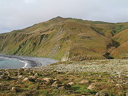
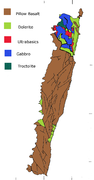
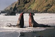
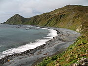
Macquarie Island (34 km long and 5 km wide) is an island in the Southern Ocean, 1,500 km southeast of Tasmania, approximately midway between the Australian and Antarctic continents. The island is the exposed top of the submarine Macquarie Ridge, currently located at the junction of the Indo-Australian and Pacific plates. This is a site of great geological preservation significance, being the only place on Earth where rocks of the mantle (6 km below the seafloor) are actively exposed above sea level. These unique exposures include excellent examples of pillow basalts and other extrusive rocks.
# Mantle rocks
# Southern Ocean
# Geological protection
# Indo-Australian Plate
# Pacific Plate
# Pillow basalt


Poem of the heritage generated by AI
Intangible culture related to the heritage
China tourist attractions related to the heritage
World heritage related to the heritage
Show more related heritage
Information extracted from Wikidata
| uses | 4099972-5 |
| country | Wet Tropics of Queensland - Component around Edmund Kennedy |
| image | http://commons.wikimedia.org/wiki/Special:FilePath/MacquarieIsland7.JPG |
| instance of | island |
| named after | Lachlan Macquarie |
| executive body | Macquarie Island |
| office held by head of the organization | http://g.co/kg/m/01c4nl |
| Commons category | Macquarie Island |
| located in time zone | Antigua Guatemala |
| time of discovery or invention | 1810-01-01T00:00:00Z |
| coordinate location | Point(158.86 -54.6) |
| topic's main category | Category:Views of Regensburg |
| page banner | http://commons.wikimedia.org/wiki/Special:FilePath/Macquarie%20Island%20banner.jpg |
| population | 20 |
| native label | Macquarie Island |
| length | 34 |
| elevation above sea level | 260 |
| area | 128 |
| area | 540000 |
| width | 5 |
| geoshape | http://commons.wikimedia.org/data/main/Data:Australia/Macquarie+Island.map |
| start time | 1997-01-01T00:00:00Z |
| official name | Macquarie Island |
| official name | جزيرة ماكَّاري |
| official name | Isla Macquarie |
| official name | Île Macquarie |
| official name | マッコーリー島 |
| official name | Macquarie eiland |
| official name | Остров Маккуори |
| official name | 麦夸里岛 |