Canal du Midi
World Heritage
France
🎧 Listen to Introduction
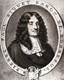
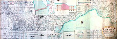
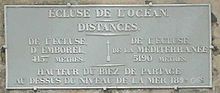
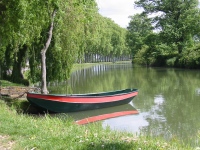
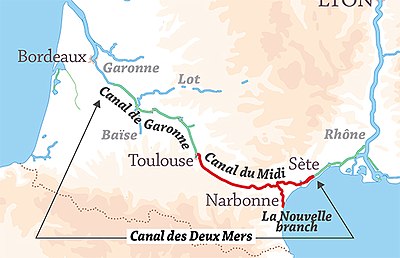
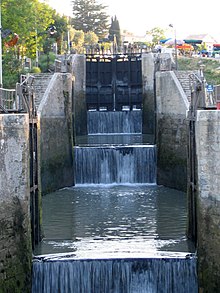
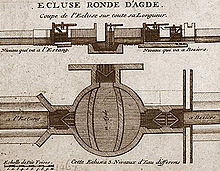
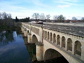
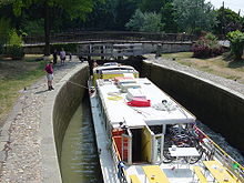
This 360-kilometre network of navigable waterways, connecting the Mediterranean and the Atlantic Ocean through 328 structures (locks, aqueducts, bridges, tunnels, etc.), is one of the most outstanding civil engineering feats of the modern era. Built between 1667 and 1694, it paved the way for the Industrial Revolution. Its creator, Pierre-Paul Riquet, put a lot of thought into its design and the way it integrates with its surroundings, turning a technical achievement into a work of art.


Poem of the heritage generated by AI
Intangible culture related to the heritage
China tourist attractions related to the heritage
World heritage related to the heritage
Show more related heritage
Information extracted from Wikidata
| uses | 4241449-0 |
| image | http://commons.wikimedia.org/wiki/Special:FilePath/Canal%20du%20Midi%2002.jpg |
| instance of | Solutrean |
| located in the administrative territorial entity | Beit Shemesh |
| located in the administrative territorial entity | Category:Views of Avignon |
| located in the administrative territorial entity | Montgiscard |
| coordinate location | Point(1.41833333 43.61111111) |
| Commons gallery | Canal du Midi |
| length | 241 |
| area | 1172 |
| watershed area | 1172 |
| World Heritage criteria | World Heritage selection criterion (vi) |
| World Heritage criteria | World Heritage selection criterion (ii) |
| World Heritage criteria | World Heritage selection criterion (i) |
| World Heritage criteria | Larousse Encyclopedia online |
| quantity | 91 |
| located in the administrative territorial entity | West Baray |
| located in the administrative territorial entity | Kerti Reserved Forest |
| located in the administrative territorial entity | Villalier |
| located in the administrative territorial entity | Ayguesvives |
| located in the administrative territorial entity | Category:Western Ghats |
| located in the administrative territorial entity | Paraza |
| located in the administrative territorial entity | Horezu |
| located in the administrative territorial entity | Category:Views of Venice |
| located in the administrative territorial entity | Villedubert |
| located in the administrative territorial entity | Siege of Acre |
| located in the administrative territorial entity | Donneville |
| located in the administrative territorial entity | Capestang |
| located in the administrative territorial entity | Villepinte |
| located in the administrative territorial entity | Béziers |
| located in the administrative territorial entity | Sallèles-d'Aude |
| located in the administrative territorial entity | Norris Geyser Basin Museum |
| located in the administrative territorial entity | Portiragnes |
| located in the administrative territorial entity | Open Data Corfu |
| located in the administrative territorial entity | Colombiers |
| located in the administrative territorial entity | Pezens |
| located in the administrative territorial entity | Pexiora |
| executive body | Canal du Midi |
| location of creation | Canal du Midi |
| indigenous to | 1172 |
| number of rooms | viaf-240424543 |
| topographic prominence | 10629 |
| office held by head of the organization | http://g.co/kg/m/019xzt |
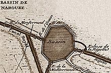
| part of | Canal des Deux-Mers |
| Commons category | Canal du Midi |
| coordinate location | Point(1.41844 43.61102) |
| elevation above sea level | 130 |
| start time | 1996-01-01T00:00:00Z |
| official name | Canal du Midi |
| official name | Canal du Midi |
| official name | Canal du Midi |
| official name | قناة ميدي |
| official name | Canal del Midi |
| official name | ミディ運河 |
| official name | Каналь-Дю-Миди (Южный канал) |
| official name | 米迪运河 |
| volume as quantity | World Heritage selection criterion (i) |
| volume as quantity | World Heritage selection criterion (ii) |
| volume as quantity | Larousse Encyclopedia online |
| volume as quantity | World Heritage selection criterion (vi) |
| heritage designation | registered historic monument |
| start time | 1996-09-19T00:00:00Z |
| area | 2014 |
| applies to part | buffer zone |
| located in the administrative territorial entity | Sète |
| coordinate location | Point(3.53978 43.34003) |