Archaeological Area and the Patriarchal Basilica of Aquileia
World Heritage
Italy
🎧 Listen to Introduction
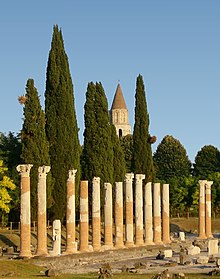
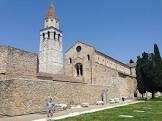
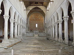
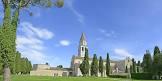
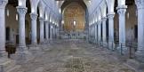
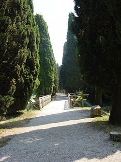
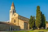
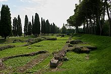
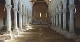
Aquileia (in Friuli Venezia Giulia) was one of the largest and richest cities of the early Roman Empire, destroyed by Attila in the middle of the 5th century. Much of its remains remain buried under fields to this day, making it the largest archaeological reserve of its kind. The Patriarchal Basilica is an outstanding building with a unique mosaic pavement, which played a key role in the evangelization of much of Central Europe.
Poem of the heritage generated by AI
Intangible culture related to the heritage
China tourist attractions related to the heritage
World heritage related to the heritage
Show more related heritage
Information extracted from Wikidata
| BHCL UUID | 504be21d-766a-4d4c-adaf-50cf020ec935 |
| date of death | Point(13.2704988 45.7532913) |
| male population | 1202897 |
| IPA transcription | 1806407 |
| visitors per year | 01661c |
| number of rooms | lccn-n50059847 |
| office held by head of the organization | http://g.co/kg/m/0k1v0 |
| postal code | 33051 |
| Commons category | Aquileia |
| licence plate code | UD |
| valid in period | standard time |
| local dialing code | 0431 |
| coordinate location | Point(13.366666666 45.766666666) |
| significant event | Siege of Aquileia |
| significant event | Rzeszów |
| Italian cadastre code | A346 |
| official website | http://www.comune.aquileia.ud.it |
| Commons gallery | Aquileia |
| page banner | http://commons.wikimedia.org/wiki/Special:FilePath/Aquilea%20banner.jpg |
| Dewey Decimal Classification | 2--45391 |
| U.S. National Archives Identifier | 10044619 |
| coordinates of northernmost point | Point(13.3900854 45.8012348) |
| coordinates of southernmost point | Point(13.3899807 45.7235956) |
| coordinates of easternmost point | Point(13.4184293 45.7424029) |
| coordinates of westernmost point | Point(13.2704988 45.7532913) |
| described by source | Edinburgh to Aberdeen Line |
| described by source | Paulys Realenzyklopädie der klassischen Altertumswissenschaft |
| category for people born here | Quintana Roo |
| native label | Aquilêe |
| category of associated people | Category:People from Aquileia |
| UN/LOCODE | ITAQZ |
| elevation above sea level | 5 |
| start time | 2020-09-01T00:00:00Z |
| uses | 4002522-6 |
| image | http://commons.wikimedia.org/wiki/Special:FilePath/Basilica%20Aquileia%201.JPG |
| image | http://commons.wikimedia.org/wiki/Special:FilePath/Basilica%20Aquileia%20110.jpg |
| instance of | comune of Italy |
| shares border with | outline of Rome |
| start time | 2000-01-01T00:00:00Z |
| end time | 0500-01-01T00:00:00Z |
| locator map image | http://commons.wikimedia.org/wiki/Special:FilePath/Map%20of%20comune%20of%20Aquileia%20%28province%20of%20Udine%2C%20region%20Friuli-Venezia%20Giulia%2C%20Italy%29.svg |
| executive body | Aquileia |
| locator map image | 006950 |
| location of creation | Aquileia |
| U.S. National Archives Identifier | 10044619 |
| population | 3369 |
| point in time | 2015-10-08T00:00:00Z |
| population | 3306 |
| determination method | demographic balance |
| point in time | 2018-01-01T00:00:00Z |
| described by source | Encyclopædia Britannica 11th edition |
| statement is subject of | EB-11 / Aquileia |
| described by source | The Nuttall Encyclopædia |
| stated as | Aquileia |
| area | 37.44 |
| point in time | 2011-10-09T00:00:00Z |